
Page 73 - David Burr Rooftops Magazine Winter 2017/2018
P. 73
A walk around Hawkedon and Upper Somerton
Distance 9km
Time 3 hours
Terrain Footpath, fields and quiet lanes
Map OS Landranger 155 or OS Explorer 210 and 211 Access Parking around Hawkedon green is limited, park carefully in front of the church; no public transport to the start but Connecting Communities offer a Dial-a-Ride service
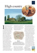
High country
If you think Suffolk is flat, then this walk, with its uncharacteristic rolling hills, will encourage you to think again as you traverse some of the highest points in East Anglia.
From the moment you arrive in this pretty village things just feel different to any of the other walks in this book. Hawkedon is an exquisite village of medieval buildings scattered around
a broad green on a south-facing hillside, with a tempting pub and a quirky and most unexpected
butcher’s shop in an adjacent small black barn. Standing alone at its
heart, surrounded by a flint wall, is
the 14th-century St Mary’s Church. Don’t miss its magnificent oak pews with carved ‘poppy head’ ends and
be sure to seek out the three moustachioed gentlemen. Head
uphill across the green, passing the church and Queen’s Head pub, and take the sunken footpath on the
right. Hop over the ford (fingers crossed it hasn’t rained too much),
and follow the path alongside a
deep ditch and around numerous wiggling field edges and fencelines. Look right and left to see the two churches visited on this walk.
Cross the stile, go left along the hedge and then back into the field you just exited. Turn right and follow the path
along the hedge into a scrubby field with a hidden gate in the top left corner. Go through the gate and continue on over the meadow. Turn right again at the road in Upper Somerton, lined with pretty cottages and large dwellings.
St Margaret’s Church has a lovely
footpath waymarkers (not those for Clare) along the field edges and downhill for approximately 1.5km to the road.
Cross the road onto the byway, go over the River Glem and continue along the track through a tunnel of trees. This wends its way uphill before turning right between two farm sheds. The views on this stretch cover the whole route so far,
revealing a rural patchwork of fields, woods, farmsteads and church towers. Turn left just before Gallowgate Farm to go through the woods and along the gently flowing river before veering half-left across the field.
Go left at the road, but first take a few paces right to see the impressive Thurston End Hall. Back on track, turn right at the road junction (for Stansfield) and take the footpath to the right after about 300m. Cross the river and head along field edges, following the path as it curves right and runs alongside Brook’s Wood. At the corner of the wood stop to enjoy the fine view of Hawkedon nestling in the folds of the hills. Cross the arable field to the road and turn left to follow
this quiet twisting lane back to the start.
n Walk taken from Suffolk: 40 Coast and Country Walks by Darren Flint and Donald Greig. Published by Pocket Mountains
hilltop position overlooking the Glem Valley; in fact, it’s one of the highest churches in Suffolk. Just after the church turn right at the ornate water pump, a good spot for a pause after all these hills, with its handy benches. Follow the
73
